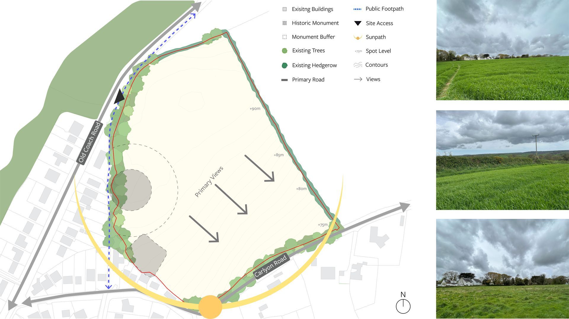
To inform our understanding of the site and its surroundings, a series of technical studies have been undertaken.
Whilst a number of studies have been undertaken across the area, there are very few technical constraints associated with the site itself. The plan below and accompanying information provides a general summary of some of the key considerations that have been taken into account when developing the initial proposals. Surveys and further reporting are on-going with final reports and findings to be submitted alongside the Planning Application.
Access: The site is accessed via a set of field gates in the northern western boundary onto Old Coach Road leading to the village centre to the south and primary school to the north. On the southern side of Old Coach Road there is an existing footway which connects to a public right of way running immediately west of the site, linking Old Coach Road to Carlyon Road. This is situated to the rear of properties fronting Old Coach Road and is separated from the site by a mature tree planted bank within the southern section. The site benefits from being located within an easy walking or cycling distance from the town centre, and Carlyon Road to the south is a designated cycle route.
Site topography: The site is south facing and generally falls in a south easterly direction at a 1:9 gradient. Aside from falling away in the north eastern corner, it is generally flat in the northern half of the site with a high point of +92m AOD. The southern half of the site falls away at a constant gradient to a low point of +73m AOD in the south eastern corner.
Flood risk and drainage: Flood risk and drainage: According to the Environment Agency Flood Map for Planning, the site is entirely located in Flood Zone 1, indicating a low risk of flooding from rivers and the sea. The Risk of Flooding from Surface Water map shows that the site is not at risk of flooding from this source. Surface water runoff from the development will be managed using Sustainable Drainage Systems (SuDS). The site is within a Critical Drainage Area which means that particular care will need be taken to ensure that the proposal replicates natural ground and surface water flows and decreases surface water runoff.
Heritage: South West Archaeology’s have completed a heritage statement with the appraisal identifying direct impacts associated with the proposed development of the site. The geophysical surveys reveal a busy archaeological landscape similar to many other sites in Cornwall, representing the usual type and range of archaeological features encountered in lowland Cornwall.
The historic Ordnance Survey maps show, in the south west corner of the site two enclosures both of which are now Scheduled. The larger one is likely to be the playing place (plain-an-gwarry) that gave the settlement its name. Completed geophysical surveys show the full extent of these features, which now largely survive only as below-ground archaeological features.
Consultation is underway with both Historic England and Cornwall Council’s heritage team to ensure that the context provided by the Scheduled Ancient Monuments is fully understood and taken into account, along with the potential opportunity to enhance this asset as part of a scheme.
Other than the Scheduled Monuments, there are relatively few designated heritage assets in the local area. Most would be screened from the housing by the topography, or else setting makes a less of a contribution to their overall significance than other values.
Landscape and visual appraisal (LVIA): LVIA work has been commenced to understand landscape and visual impact issues and to inform the emerging proposals.
The site does not sit within any National Landscapes, conservation areas or SSSIs with the closest National Landscape being the South Central Coast (formerly AONB).
Ecology: Plan For Ecology have conducted a Preliminary Ecological Assessment of the site. No part of the site lies within a designated wildlife site and there are no statutory designated sites present within 1km of the site. Within the site there is one habitat that has been assessed as being of ‘Local Value’, the species-rich native hedgerows.